|
Kenyan Geography
|
| thecommonwealth.org |
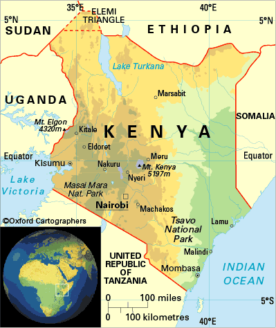
Kenya, located on the equator east-central Africa, is roughly twice the
size of Nevada. With part of its south-eastern border on
the Indian Ocean, Kenya’s other sides are bordered by Somalia, Ethiopia, Sudan,
Uganda, Tanzania, and
Lake Victoria.
Landforms:
Several plateaus rise from coastal Kenya, spreading like steps into the interior. This, along
with many mountain peaks and low valleys, are huge factors in Kenya's
climate and ecology.
Climate:
The creation of the
Great Rift Valley also caused huge climatic changes. Before its creation, Kenya had a tropical climate. Today, however, climates range from temperate to
alpine, semi-arid to tropical, and even arctic.
Regions:
Kenya has three regions, each with its own climate and vegetation.
Coast:
Kenya’s coast runs along the Indian Ocean, with Somalia in the north and Tanzania
in the south. The area's beaches are protected by barrier reefs. These reefs have been used in coastal cities for building
materials. The coast has three marine parks; Kisite, Watumu, and Malindi. Rainfall is plentiful with 40-50 inches per year,
but falls in short spurts, except during the monsoon season from April to June. The climate is hot and humid with steady temperatures
that rarely stray from the averages. Sugar cane grows well there because of the region's low-lying and fertile land.
Interior: Beyond the coast, a plateau rises to the central Highlands in the
south and the country of Ethiopia in the
north. In the northeastern part of the plateau, there is little variety in the land, with little vegetation other than the
occasional thorn or boabab tree. The region, with its arid and semi-arid climate, is more extreme than the
rest of Kenya since temperatures
can range from 104 degrees during the day to 68 degrees at night. The entire northern part of the plateau is agriculturally
unproductive, and therefore is sparsely populated. There are few towns or roads, leaving huge expanses of untouched land. The only
human inhabitants of the area are nomads, forever seeking water for their cattle and themselves.
To
the east of the Rift Valley are the Aberdare Mountains,
which include Mount Kenya; while to the west is the Mau Escarpment. The eastern
Highlands are very fertile because of frequent rain and rich volcanic soil, and has been cultivated by Europeans as well
as Kenyans.
South-central Kenya first became known as the Highlands by the Europeans during the
colonial days. The area has many deep valleys, canyons, and mountains, making it much more geographically varied than
the rest of the Interior. It is also the most fertile part of the Interior, and also the most thickly populated. The
climate is generally considered temperate, but there's a huge difference in temperature and precipitation between the
valleys and the mountains. Rainy seasons occur twice a year: between March and May with the long rains, and again between
October and December with the short rains.
Western Kenya: Western Kenya is, essentially, a huge plateau that runs across the entire country. It has a
hot and humid climate with abundant rain to support the plentiful wildlife and thick tropical forests that the region
hosts. In the northern part of Western Kenya is Mount Elgon. The land south of the mountain
includes Lake Victoria, the world's second largest lake, and becomes less fertile the
farther south you move. The southern area is full of game preserves, including Maasai Mara and Tsavo.
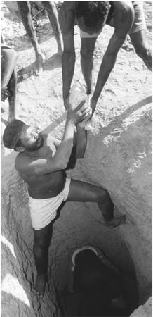
| Men Working in a Gold Mine |
|
| everyculture.com |
Natural Resources: Kenya
and other parts of East Africa contain much of the world's manganese, platinum, diamonds,
and gold. Other resources include large amounts of coal and iron ore, in addition to natural gas and other minerals. Resources
mostly unique to Kenya are soda ash, gold,
limestone, rubies, and garnets.
|